Here’s the latest information from the National Weather Service:
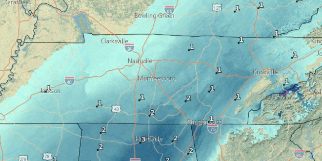
...Wintry Conditions Expected Late Tonight and Tuesday... .An arctic cold front will move across the Tennessee Valley and southern Appalachians late Tonight and Tuesday morning bringing with it widespread precipitation. The precipitation will likely begin as a mixture of rain and snow but quickly transition to all snow around daybreak Tuesday morning. Snow and ice covered roadways are expected area-wide causing travel problems.

...WINTER WEATHER ADVISORY IN EFFECT FROM 4 AM EST /3 AM CST/ TO 4 PM EST /3 PM CST/ TUESDAY... * WHAT...Snow expected. Total snow accumulations of 2 to 3 inches   expected. * WHERE...Most of East Tennessee, Southwest Virginia and   Southwest North Carolina. * WHEN...From 4 AM EST /3 AM CST/ to 4 PM EST /3 PM CST/ Tuesday. * ADDITIONAL DETAILS...Plan on slippery road conditions. Since   temperatures will be dropping during the day Tuesday, snow and   ice covered roadways are likely. Hazardous driving conditions   can be expected that will likely impact the morning or evening   commute. PRECAUTIONARY/PREPAREDNESS ACTIONS... A Winter Weather Advisory for snow means periods of snow will cause primarily travel difficulties. Expect snow covered roads and limited visibilities, and use caution while driving. &&
 Mocs News Reporting the news that matters most to UTC


